|
MAYO LAKE MINERALS - YUKON PROPERTIES
SYNOPSIS PROPERTIES FLAGSHIP Carlin-Roop EARLY-MID STAGE Anderson-Davidson Trail-Minto BLUE SKY Edmonton Cascade GEOLOGIC OVERVIEW Yukon Mayo Lake Area Geology Mayo Lake Area Mineralization REPORTS November 17, 2021 Carlin-Roop NI 43-101 Technical Report Carlin-Roop Silver Project, Mayo Lake District, Yukon Territory, Canada |
ANDERSON-DAVIDSON CLAIMS
The Anderson-Davidson Claims currently comprise 627 contiguous quartz claims covering an area of 129.4 square kilometres, near the community of Mayo, Yukon Territory. The Anderson-Davidson Claims are 30 kilometres long and cover the highlands south of Mayo Lake where several placer operations actively recover gold from creeks draining the highlands (Figure 16). Access to the Anderson-Davidson Claims is provided by a seasonal road connecting placer operations on Davidson Creek to the all-weather Mayo Lake Road. A pre-existing, four-wheel drive track runs east-west through the center of the Anderson-Davidson Claims. The Anderson-Davidson Claims are also accessible by boat from Mayo Lake and by helicopter from the airport in Mayo. The Anderson-Davidson Claims are underlain by phyllites, schists and carbonates of the Hyland Group, occasionally intruded by felsic dykes. Most stratigraphy has bedding parallel or sub-parallel to foliation, which dips shallowly generally southeast except where modified by small scale isoclinal folding. The area covered by the Anderson-Davidson Claims has been subjected to multiple glaciations. The surface cover is a mixture of colluvium and till. Rock exposure is less than 5 percent. During an older glaciation, the uplands were covered by glacial ice that was probably cold-based with the transport of rock and debris being minimal. The Anderson-Davidson Claims have a long history of placer mining. Currently, Davidson Creek is being mined during the summer, whereas the Anderson Creek and another locale, Dawn Gulch are operated sporadically. Several creeks draining the north part of the property covered by the Anderson-Davidson Claims were sampled by the Geological Survey of Canada in the 1960s yielded up to 275,000 ppm Au in heavy mineral concentrates. The Company delineated numerous areas of anomalous gold from ridge and spur sampling in 2012. Further testing of one promising area by the Company delineated the Anderson Gold Trend, a 10-kilometre-long zone of elevated and anomalous Au-As-Sb values (Figure 7). Three gold-in-soil anomalies with zones of greater than 50 ppb Au for lengths of 200 m plus strike length within trends of elevated Au up to 2 km long were identified within the Anderson Gold Trend from 2013 to 2015 sampling; Owl-Anderson, Steep Creek and the Peak anomalies (Figures 17, 18 and 19). Significant sections of these soil anomalies contain greater than 100 ppb Au with others up to 500 ppb. A trench excavated at the Anderson-Owl Occurrence yielded anomalous gold in soil samples and a grab sample that assayed 3.5 g Au/t. These targets remain open along strike in up to three directions, in some cases following or crossing untested topographic depressions. Many geochemical targets remain to be tested, both within and outside of the Anderson Gold Trend. On the Davidson Claims, stream sediment and soil sampling by the Company has identified a number of gold anomalies ranging from 400 m to 1500 m in length with associated Sb and As halos (Figure 20). One Au target was verified with a SGH survey. Some of the grids need extending to better determine the probable bedrock source of the Davidson Creek placers. At the Anderson-Davidson Claims, a 2017 scout reverse circulation (RC) drilling campaign conducted by the Company tested the Anderson-Owl anomaly within the Anderson Gold Trend and intersected a gold-bearing system in drift covered bedrock. In total, 640 m was drilled by the Company in 8 RC holes on two separate fences 50 m apart. The newly discovered bedrock vein gold system had two mineralized structures, which correlated across both fences. The quartz sulfide vein structures had significant Au+As+Sb+Hg and contained abundant stibnite-arsenopyrite-pyrite mineralization associated with quartz veins and silica-cemented breccia. One structure (Alpha) yielded 0.77g Au/t over 6.1 m, from the bedrock-drift interface in RCH MLM17-005 (Figure 21). Within this hole a 3.1m interval yielded 0.90 g Au/t from 4.6 m down-hole. Gold grades were highest at the bedrock–drift interface. The structure appears continuous for at least 50 m between holes. The width and grade of the Alpha structure could not be determined because the drill entered into the structure at the bedrock-drift interface. The higher grades of gold at the top of the holes suggest that gold grades could increase in the undrilled part of the structure. Subject to the availability of funds, the Company is planning to (i) refine the drill targets at the Alpha structure and other known gold in soil anomalies within the Anderson Gold Trend, (ii) locate other gold in soil anomalies within the Anderson Gold Trend that merit drill testing and (iii) diamond drill the Alpha structure and other well defined drill targets. Other prospective areas are present at the Anderson-Davidson Claims that merit further exploration, specifically in the vicinity of the Davidson Creek placer operations. 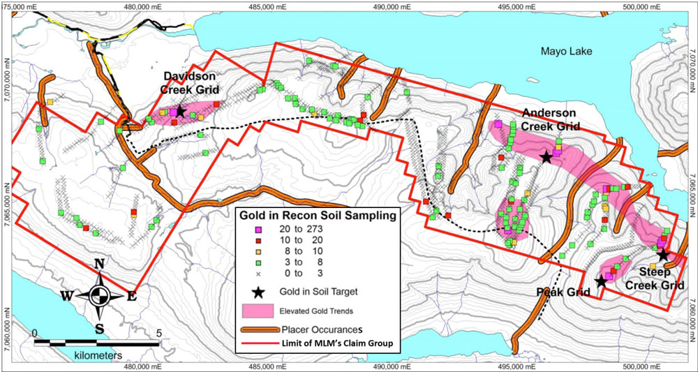
Figure 16. Anderson-Davidson showing major placer operations and significant Au in soil anomalies from reconnaissance sampling that have been grided for identification of drill targets.
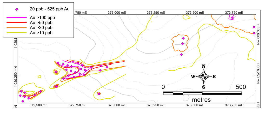
Figure 17. The Owl-Anderson gold in soil anomaly.
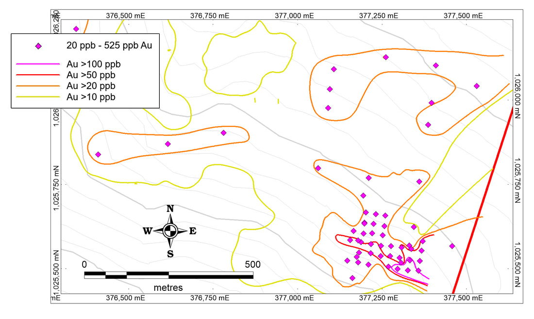
Figure 18. The Steep Creek gold in soil anomaly.
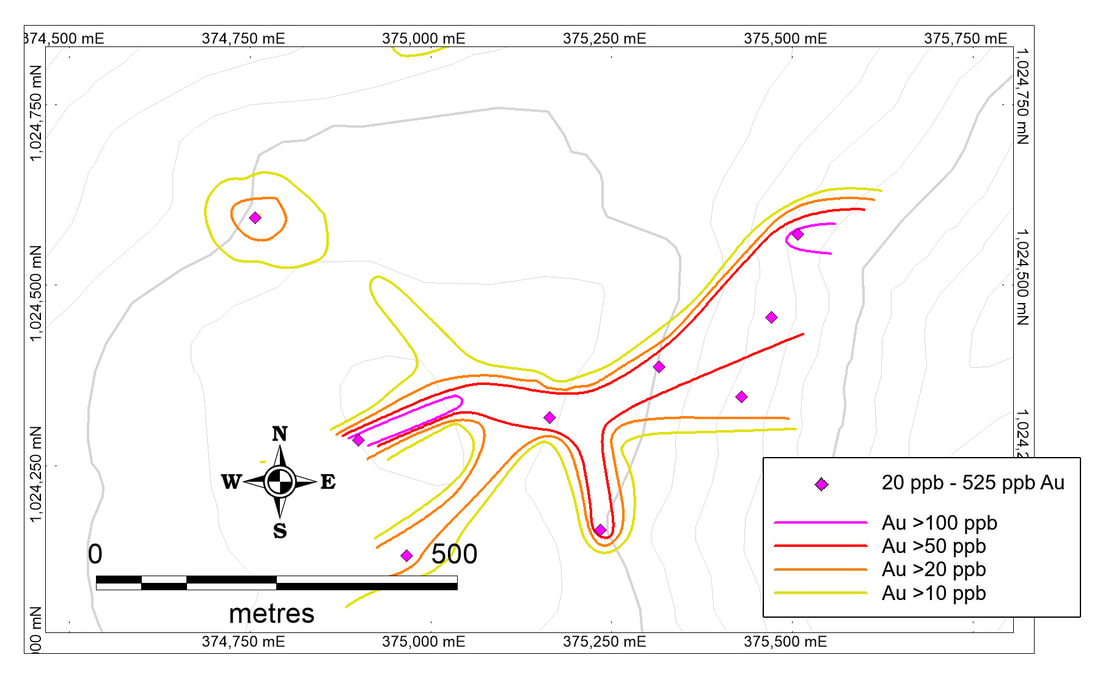
Figure 19. The Peak gold in soil anomaly.
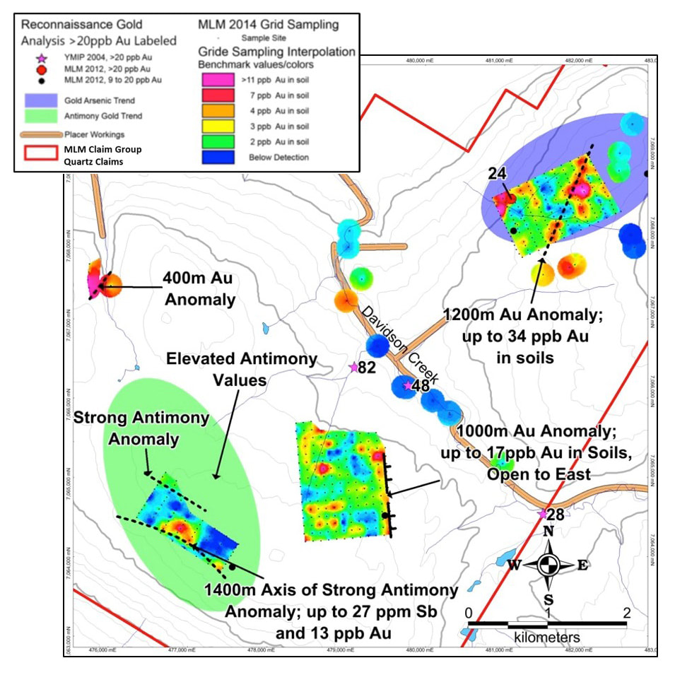
Figure 20. Highlights from sampling of soils and stream sediments on Davidson Creek. The grid at the NE part of the figure was tested with a SGH grid and identified a gold drill target in the vicinity of the gold in soil anomaly.
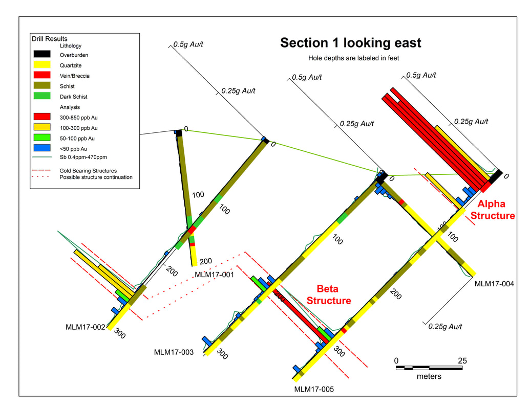
Figure 21. Drill logs showing gold assays on section 1 at Owl-Anderson gold occurrence.
|

|
MAILING ADDRESS
Mayo Lake Minerals Box 158, Carp On K0A 1L0 |
|