|
MAYO LAKE MINERALS - YUKON PROPERTIES
SYNOPSIS PROPERTIES FLAGSHIP Carlin-Roop EARLY-MID STAGE Anderson-Davidson Trail-Minto BLUE SKY Edmonton Cascade GEOLOGIC OVERVIEW Yukon Mayo Lake Area Geology Mayo Lake Area Mineralization REPORTS November 17, 2021 Carlin-Roop NI 43-101 Technical Report Carlin-Roop Silver Project, Mayo Lake District, Yukon Territory, Canada |
EDMONTON CLAIM GROUP
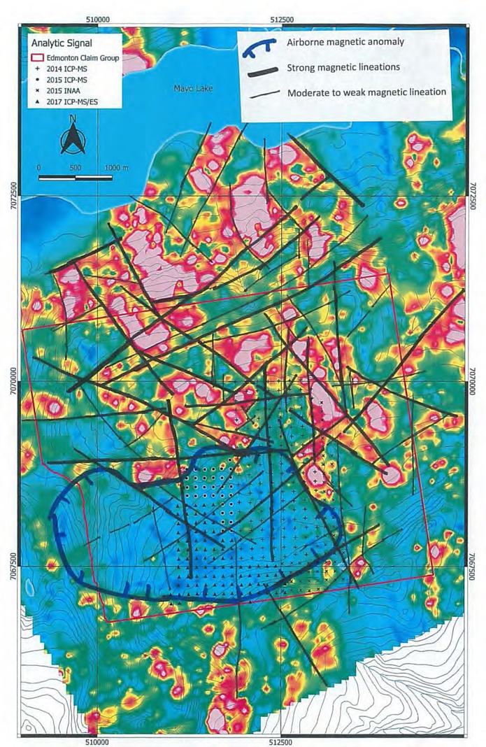
The Edmonton claim group is composed of 76 contiguous quartz claims covering an area of 19.5 square kilometres near the eastern arm of Mayo Lake. Access is primarily by helicopter. The claim group is also accessible from Mayo Lake. It is bordered to the west by Edmonton Creek, a historically active placer creek. Other creeks that drain to the east are shown to have been placer mined in the past. The surface cover at Edmonton is a mixture of colluvium and till. The youngest glaciation affecting Edmonton, was confined to the valley occupied by Mayo Lake. This valley was filled with westward fast-flowing ice that scoured its bottoms and sides. The youngest glacial limits are marked by moraines. Small ice-damed ponds are present along the periphery of this moraine system. The highest part of uplands was probably covered by older cold-based glacial ice during an older glaciation, transport of rock and debris being minimal. Edmonton is underlain by the Robert Service Thrust (RST), which is a broad structure containing a complex intermingling of Keno Hill Quartzites and Hyland Group metasediments intruded by competent gabbroic rocks (Figure 24). The thrust limit of the RST is mapped as a surface trace on Edmonton. Reconnaissance mapping in the area suggests that the RST is in the form of a series of multiple faults across a broad width, each showing northerly movement. The rocks have also been intensively strained during Tombstone thrusting. Airborne magnetics was flown over the property in 2012. It delineated a large geophysical anomaly in the southern part of the claim group with one boundary that is marked by elevated gold in soil values. This large anomaly is interpreted to be a buried stock or alteration zone of unknown provenance. Other magnetic lineations clearly showed faults and fractures that are common within the Tombstone strain zone (Figure 25). Later soil sampling confirmed the presence of the large airborne magnetic low and certain lineations. Staged definition geochemical soil sampling was completed in 2014, 2015, 2017, the later being reported in 2018. It delineated an E-W trending Au anomaly along the northern edge of the large mag low. Other gold and base metal soil anomalies are also evident. A thorough interpretation of the geophysical, geochemical and glacial history of the data was completed in 2019. It became evident that base metal anomalies formed a ring around the large mag low in the southern part of the property (Figure 9). Slightly elevated, variably trending Au anomalies were present in the centre of the mag low. A strong multi-element anomaly trended to the northeast from the mag low. The geochem anomalies were commonly parallel to geophysical linears suggestive of fractures and faulting related to the Tombstone thrusting. The pattern of geochem anomalies and geophysical suggests that base metal mineralization along the flanks of the mag low and Au mineralization within and along the north flank of the mag low reflect fluids from different magmas. In the future, subject to funding, MLM plans to investigate the mineralization related to the large magnetic low on the property with a combination of SGH and IP-Resistivity surveying in order to define trenching and drill targets. 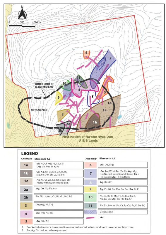
Figure 9. Summary diagram showing outline of large magnetic lows and gold, silver and polymetallic anomalies. The linear gold anomalies and enhancements follow faults and joint patterns within the magnetic low.
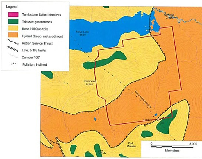
Figure 24. Property geology from Roots 1997 with modifications (original staked and present smaller extent of Edmonton property on figure).
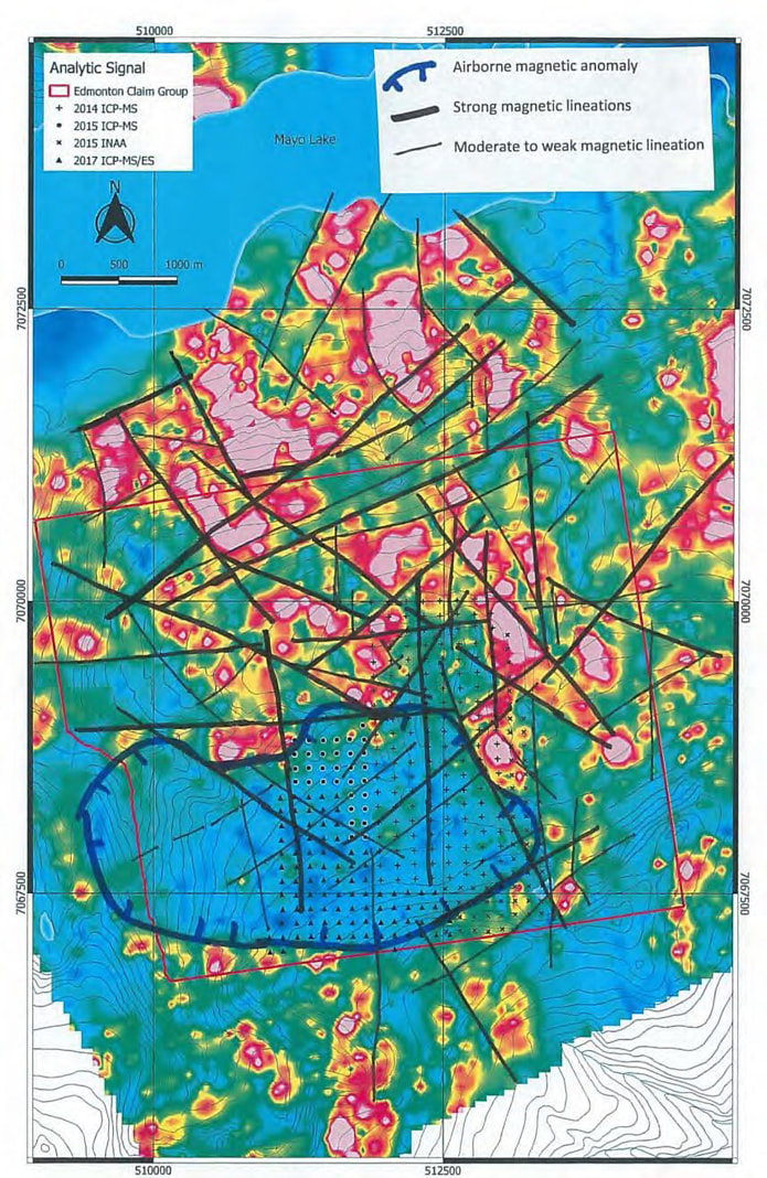
Figure 25. Major E-W trending magnetic low and lineations as determined from airborne total magnetics and analytical signal.
|


|
MAILING ADDRESS
Mayo Lake Minerals Box 158, Carp On K0A 1L0 |
|