|
MAYO LAKE MINERALS - YUKON PROPERTIES
SYNOPSIS PROPERTIES FLAGSHIP Carlin-Roop EARLY-MID STAGE Anderson-Davidson Trail-Minto BLUE SKY Edmonton Cascade GEOLOGIC OVERVIEW Yukon Mayo Lake Area Geology Mayo Lake Area Mineralization REPORTS November 17, 2021 Carlin-Roop NI 43-101 Technical Report Carlin-Roop Silver Project, Mayo Lake District, Yukon Territory, Canada |
PROJECT - CARLIN-ROOP
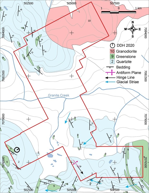
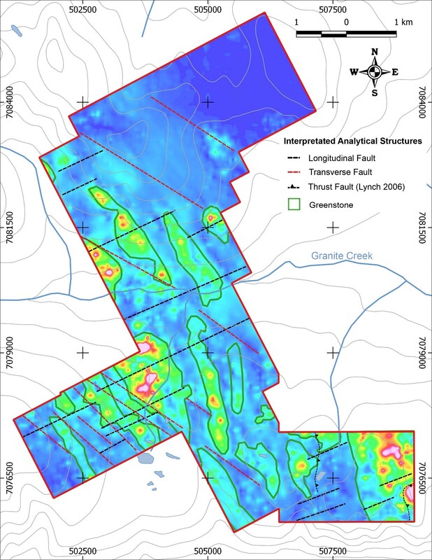
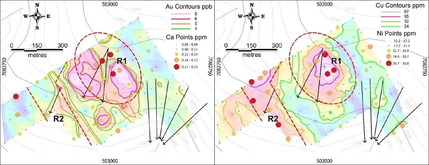
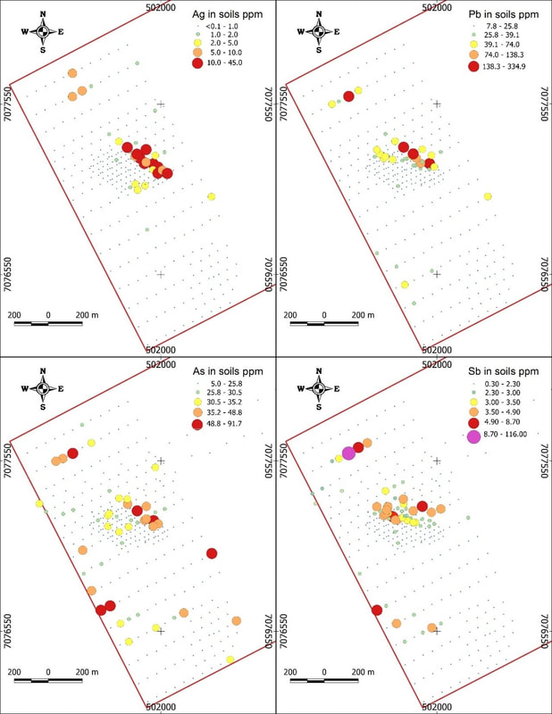
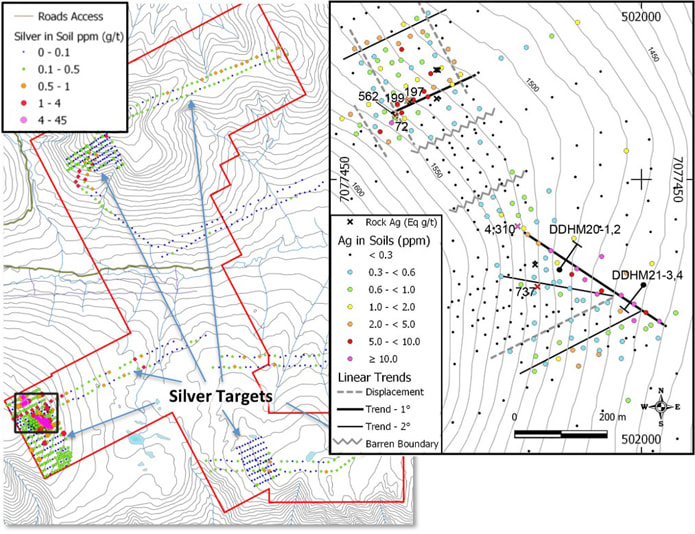
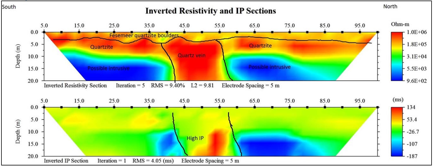
Carlin-Roop is composed of 186 contiguous quartz claims covering an area of 36.3 square kilometres. The property covers the eastern reaches of the Gustavus Range, which is bisected by the broad west to east flowing Granite Creek valley. Peaks are generally rounded with steep drop-offs or cliffs at the lips of valleys. Carlin-Roop lies within the Eastern Sector of the Keno Hill Silver District (KHSD) (Figure 2) where Keno Hill Style Mineralization (KHSM) high-grade silver ore. The KHSD has produced over 200 million ounces of silver from over 5.3 million tonnes of ore with an average grade of 44 ounces/t of silver. Alexco Resource Corp., a mining company based in Vancouver, is presently mining near Keno Hill from a reserve of 1,438,349 tonnes of ore with a grade of 804g Ag/t. Other companies, such as Metallic Minerals Corp. and Alianza Minerals Ltd., are continuing with drill programs in the area to discover and define KHSM and silver ore. Granite Creek was historically prospected for placer potential. Beginning in 2013, a placer operation has been active and pockets containing up to 300 ounces of gold have been mined. Many of the tributaries to Granite Creek have been staked for additional placer potential. The placer operation on Granite Creek and Carlin-Roop can be accessed by a road originating in Keno. Carlin-Roop is underlain by structurally deformed and altered Keno Hill Quartzite (KHQ) interlayered with minor andesitic volcanics and intruded by Triassic gabbros silts and plugs (Greenstones) (Figure 11), near-identical to those hosting high-grade silver mineralization at the Keno Hill Silver mines. In addition contact metamorphic aureole extends up to 4 kilometres away from the Roop Lake Stock, which is present on the northeast part of the property. It impacts most units underlying the property. The property has been glaciated with glacial limits are well marked by lateral moraines and lateral meltwater channels. Above the glacial limit, the ice was probably cold-based, resulting in minimal erosion. Within the Granite Creek valley most of the terrain is now covered by variable thicknesses of till. Airborne magnetics were flown over the large area covered by the two claim groups in 2012. Magnetic patterns clearly showed the Roop Lake Stock and mafic plugs and a broad NNW trending mag low on the west side of the Roop Lake Stock. A NW trending anticline parallel the mag low with most of the area being underlain by the KHQ and Greenstones. The airborne magnetics defines numerous parallel breaks and terminations in the magnetics (Figure 12). These lineations are related to fracturing and folding patterns, induced by the Tombstone Thrust and can serve as pathways for fluids an magma. MAYO completed soil sampling at various scales on the property in 2012, 2014, 2015 and 2016. It delineated several geochemical targets. The geochemistry and a follow-up SGH survey has indicated potential for Au bearing veins, copper of unknown provenance and for Keno Hill type Ag ± Pb ± Zn veins. At the northern extremity an Au and Ag target plus a copper target have been defined by soil sampling and SGH (Figure 13). In the southern area soil sampling has indication Au and Ag potential at two localities; some Ag pathfinders indicate a potential for a KHSM silver mineralization in the east-central part of the property. In the western part of the property, highly anomalous Ag, Zn, Pb Sb and As are present over two segments of soil anomaly totaling 1000m in length (Figure 5 and 14a). One has a length of 600m (Carlin West occurrence) and trends at an azimuth of 310° (WSW). It in turn is cut by liners trending 60° (ESE) with the same elements paralleling this trend (Figure 14a). This situation is similar to that in the central KHSD where Ag fault veins are focused along the Tombstone-related fractures and faults. In 2018, a ground magnetics survey was completed over parts of the 600m long soil anomaly to confirm and refine the position of the soil anomaly s projected by the airborne magnetics. In 2019, IP-Resistivity survey across the soil anomaly indicated the probability of a 15m wide steeply dipping high silica, mineralized zone, crossing the axis of the Ag soil anomaly at the Carlin West occurrence (Figure 15). The values associated with the geochemical and geophysical anomalies met and exceeded those values obtained by other surveys throughout much of the KHSD. In late October of 2020, a short drill program, 2 holes totalling 205m, was completed, but was terminated prior to achieving its objectives due to severe weather. The first hole was drilled to 127.5m depth and intersected a greenstone unit (Greenstone) below the Keno Hill Quartzite (KHQ) at 93.5m downhole (Figure 6). The Greenstone is secondary to the KHQ in acting as a host to Keno Hill Style Mineralization (KHSM). Nevertheless, a classic KHS breccia, which yielded values of 6.9 g Ag/t over 1.85m, including 12.8g Ag/t over 0.85m, was cored in the Greenstone.. These breccias generally increase in widths and grades by orders of magnitude when intersected within the KHQ. Structural measurements indicate that this breccia likely intersects the KHQ 5-10m above where the drill cored into the Greenstone. N ew intervals of KHSM from the two hole collars to 20m downhole drilled through interbedded graphitic schist and quartzite. Assays from many prospective quartz vein and breccia intervals in this new zone assayed to 2.65m at 64.4 g Ag/t from 16.1m, including 0.85m at 124.4g Ag/t from 18m in the second hole; and 0.5m at 18.3g Ag/t from 21.5m and 1.0m at 33.7g Ag/t from 82.5m in the first hole. Structural measurements from the first hole indicate that the drilling did not intercept the 15m wide IP anomaly within the KHQ. During the summer of 2021, prospecting and detailed soil grids were completed in the vicinity of the Carlin West occurrence to locate more zones similar to those at Carlin West. The soil surveys defined another four Ag ± Pb, Zn, Sb, As soil zones, one particularly strong (Figure 14b). Numerous grab samples along these zones were anomalous ranging from 72 to > 1.318 ppm Ag. Two diamond drill holes (Figure 14b for locations) were completed on the Carlin West showing in October of 2021. A preliminary examination of the core indicates similar bedrock lithologies to those found in the 2020 diamond drill holes. Assay results are not anticipated until 2022. |
|
MAILING ADDRESS
Mayo Lake Minerals Box 158, Carp On K0A 1L0 |
|
