|
MAYO LAKE MINERALS - YUKON PROPERTIES
SYNOPSIS PROPERTIES FLAGSHIP Carlin-Roop EARLY-MID STAGE Anderson-Davidson Trail-Minto BLUE SKY Edmonton Cascade GEOLOGIC OVERVIEW Yukon Mayo Lake Area Geology Mayo Lake Area Mineralization REPORTS November 17, 2021 Carlin-Roop NI 43-101 Technical Report Carlin-Roop Silver Project, Mayo Lake District, Yukon Territory, Canada |
TRAIL-MINTO CLAIM GROUP
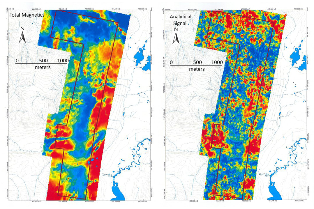
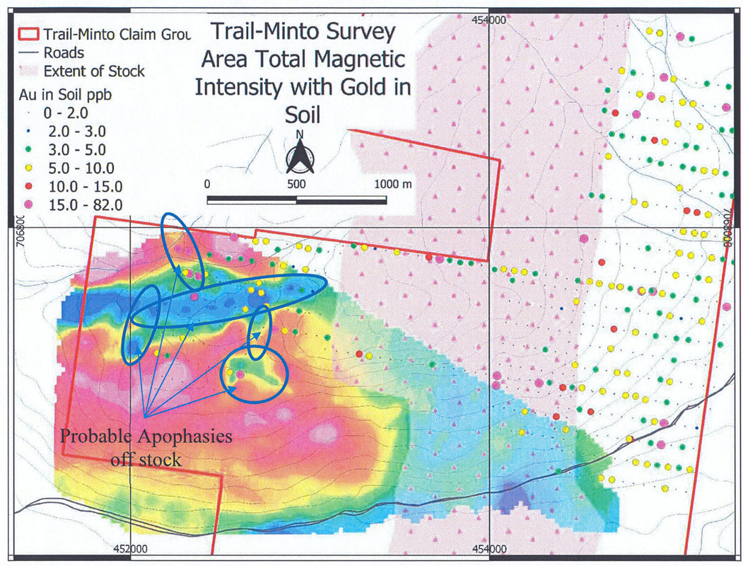
Trail-Minto is composed of 184 contiguous quartz claims covering an area of 36.5 square kilometres. Trail-Minto is over 15 kilometres long and covers the highlands west of Silver Trail and south of Mount Haldane. Access to Trail-Minto is provided by two pre-existing seasonal roads that cut across the northern and southern edges of the claim group. The roads connect to the Silver Trail Highway, 2.5 kilometres east of the property. Two past producing placer operations are present on creeks draining the property. Trail-Minto is underlain by phyllites, schists and carbonates of the Hyland Group metasediments, occasionally intruded by felsic and mafic plugs and dykes. Most stratigraphy has bedding parallel or sub-parallel to foliation, which generally dips shallowly southeast except where modified by small scale isoclinal folding. The Roaring Fork Stock underlies the south part of the Trail-Minto. Isolated small intrusive plugs are exposed in the northern part of the property. The uplands within Trail-Minto are covered by a mixture of colluvium and till. Outcrop is sparse on the property, rarely exceeding 5 per cent. Trail Minto has been subjected to multiple glaciations, but lies beyond the western limit of the most recent glaciation. Due to the elevation of the upland, ice was probably cold-based and transport of rock and debris was minimal. Airborne magnetics flown by MAYO in 2012 delineated patterns that were indicative of (i) an underlying N-S oriented intrusion or alteration in the southern two-thirds of the property and (ii) a broader E-W oriented buried intrusion in the northern one-third of the property where small mafic and granodiorite plugs outcrop (Figure 22). Magnetic lineations primarily parallel or are oblique to the major oblong magnetic anomalies. The N-S oriented pattern relates to the Roaring Fork Stock. A ground magnetic survey completed in 2018 confirmed that a major linear magnetic low projecting from the west part of the Roaring Creek Stock and adjacent small lows in the surrounding area represent apophasis of the Stock (Figure 23). In 2019 a shallow penetrating IP-Resistivity line identified the contact between the Stock and adjacent schistose rock. Reconnaissance-type soil sampling completed by MAYO in 2012 and 2015 outlined a number of WNW trending Au+As+Sb anomalies in the northern part of the property. Soil sampling completed in 2012, 2015 and 2016 over the southern part of the property adjacent to the Roaring Fork Stock and its buried projections is characterized by Au in soil anomalies that generally have a N-S orientation with some obliquely-oriented variations (Figure 8). Contours for other elements also define patterns that reflect the presence of the Roaring Fork Stock, alteration of the Stock and adjacent wallrock mineralization. The gold mineralization appears to have been transported and precipitated along faults and joints within the Roaring Fork Stock and the adjacent altered wallrock; the mineralization, faults and joints being in part induced by the Stock. Gold mineralization is expected to be intrusion related, such as at Victoria Gold’s Eagle deposit, or structurally controlled intrusion related mesothermal or epithermal gold bearing veins and stockworks. In the near future, funds available, MAYO plans to trench Au in soil anomalies that it has delineated within, and adjacent to, the Roaring Fork Stock. This will determine priority targets for subsequent drilling. Subject to availability of funds, a large area over the Roaring Fork Stock will be sampled for determination of multielement, including Au, content in soils. 
Figure 22. Airborne magnetics. Total Mag well defines broad lows and highs and strong NNE and ENE lineations. Analytical Signal defines the shallow extent of intrusives alteration zones and rock types. More subtle and widespread NNW, NW, NE and E-W lineations representing joint and faults and sharp changes in lithologies are also better defined on the analytical signal.
|
|
MAILING ADDRESS
Mayo Lake Minerals Box 158, Carp On K0A 1L0 |
|


