|
MAYO LAKE MINERALS - YUKON PROPERTIES
SYNOPSIS PROPERTIES FLAGSHIP Carlin-Roop EARLY-MID STAGE Anderson-Davidson Trail-Minto BLUE SKY Edmonton Cascade GEOLOGIC OVERVIEW Yukon Mayo Lake Area Geology Mayo Lake Area Mineralization REPORTS November 17, 2021 Carlin-Roop NI 43-101 Technical Report Carlin-Roop Silver Project, Mayo Lake District, Yukon Territory, Canada |
Mayo Lake Minerals - Yukon Properties
SYNOPSIS
Mayo Lake Minerals Inc. (C: MLKM) recently launched as a public company on the Canadian Securities Exchange (‘CSE’) on May 5, 2022. Since its 2011 inception as a private company, immediately followed by its staking of numerous highly prospective gold and silver claims in the Mayo Lake area of the Yukon, the focus of its exploration has concentrated on locating the bedrock sources of the many gold placer deposits on its 4 large gold properties and more recently its exciting discovery of silver on its promising Carlin -Roop property, located in proximity to Alexco’s producing silver mines. Miners in the district have consistently produced gold from creeks for over 100 years and have always believed that the gold’s source is located in the uplands surrounding the placer creeks. Prior to MAYO acquiring the properties in 2011, little modern exploration was ever completed in the areas covered by MAYO’s projects. MAYO believes that the Mayo placer district has the same potential as the White Gold district south of Dawson City where a number of projects are moving forward to mine development. Nearly every creek in the Mayo district is a current or past producer of gold, but very little modern exploration techniques have been employed in the surrounding area in the search for gold. During the interval beginning in around 2019, MAYO began to realize that a 600m plus long, very anomalous silver in soil anomaly on its Carlin-Roop Property lay within the Eastern Sector of the Keno Hill Silver District. The rocks, structures and mineralization underlaying most of the Carlin-Roop were very similar to those at the Keno Hill Silver District. MAYO’s focus has since nearly completely turned to exploration of Carlin-Roop. Mayo is the center of mining investment for silver and gold in the Yukon (Figure 3). Active mines include Victoria Gold’s Eagle Gold mine with commercial production initiated on July 1, 2020; and Alexco Resources’ Keno Hill Silver Mines with mining beginning in Q1 2021. Metallic Minerals, whose properties are to the east of Alexco’s holdings and north of MAYO’s has confirmed the silver prospectivity of the Eastern Sector of Keno Hill Silver District with their 2020 drill program (Figure 2). They plan to spend a further $10M exploring their Keno projects this year, mainly on drilling. Alianza Minerals also drilled 1.26m at 3267 Ag/t (~ 100 oz Ag/t) in June on its silver project in the Western Sector of the Keno Hill Silver District. The area immediately to the northwest of Carlin-Roop has gold prospectivity also. Strategic Metals has optioned its Mount Hinton precious metal property to Canada Mining Corp, who must incur exploration expenditures of $5M by December, 2022, $10M by December, 2024 for a 50% interest. MAYO successfully defined highly prospective areas and drill targets after it completed airborne magnetics (Figure 4) over all its properties and reconnaissance and grid soil sampling over a portion of its properties. This was followed by detailed grid sampling, ground geophysics and limited percussion probing and trenching. A good proportion of each property has yet to be screened fully by soil geochemistry or prospecting. MAYO’s Carlin-Roop and Anderson-Davidson projects are fully permitted for advanced exploration. During the early winter of 2020, a 2 hole 205m diamond drill program identified Keno Hill Silver Mineralization (narrow, potentially high-grade silver mineralization) in two zones at its Carlin-Roop property (Figure 5). On Anderson-Davidson, MAYO has defined a 10-kilometre-long gold trend with three drill-ready gold targets (Figure 6). Trail-Minto has an attractive 3.5km long gold in soil anomalies associated with a prospective intrusive and its surrounding alteration zone. Attractive geophysical and geochemical anomalies have been identified on both Edmonton and Cascade properties that indicate gold and base metal potential. Much of the properties have yet to be screened by geochemical or geophysical surveys. 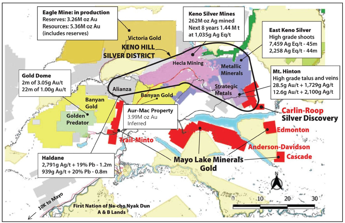
Figure 3. Prolific Mineral Setting in the Mayo Mining District.
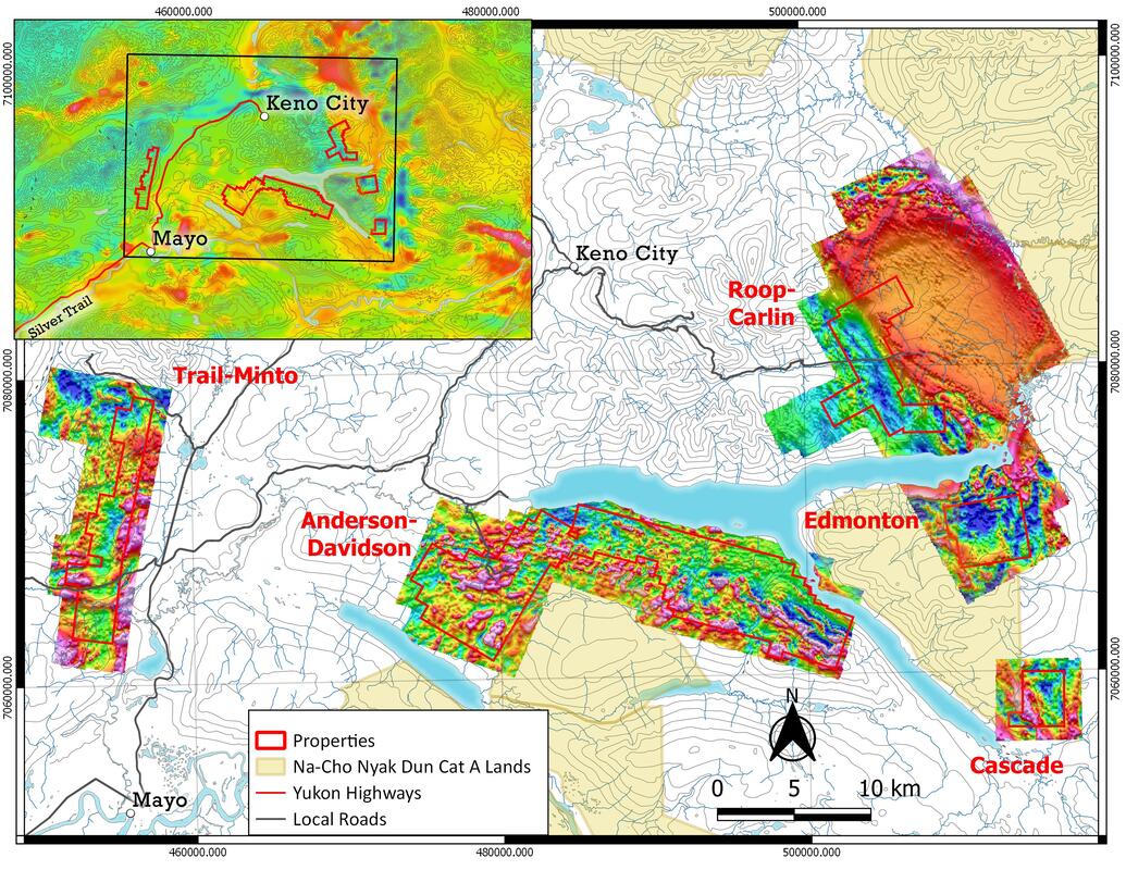
Figure 4. Detailed and regional total magnetic intensity on Mayo Lake Minerals properties. Keno City is in the centre of Keno Hill Silver District, which includes Carlin-Roop.
PROPERTIES
Carlin–Roop is located on the eastern margin of the Keno Hill Silver District and is fully permitted for advanced exploration. It is MAYO’s flagship property. A 600m plus long silver in soil zone with a core zone containing samples that assay between 15-45g Ag/t in soil is present in the west part of the property at Carlin-Roop (Figure 5). Shallow IP-Res indicates a 15m wide zone of silicification and mineralization and a 2 hole scout drill program has shown the presence of two zones of Keno Hill Style Mineralization in rocks similar to those at the Keno Hill high-grade silver mines (Figure 6). The bedrock underlying Carlin-Roop is very similar to that at the Keno Hill silver mines with its characteristic structured and mineralization. Twelve more holes totalling 1070m were drilled in 2022; assays are pending. Anderson-Davidson is also fully permitted for advanced exploration with three drill ready targets within the greater than 20km long Anderson Gold Trend (Figure 7). Other positive indications for gold mineralization are two producing placer operations, as well as numerous former placer producers. Test pits have yielded float, assaying up to 3.5g Au/t within 2 Km gold in soil anomaly. A 640 metre reverse circulation drill program tested one anomaly within the Anderson Gold Trend and intersected a gold-bearing system. One structure yielded 0.77g Au/t over 6.1m, including 0.90 g Au/t over 3.1m. Anderson-Davidson has a four-wheel-drive road that runs the length of the claim group for which MLM has initial permitting to potentially upgrade. Twelve anomalous zones totaling over 13,000m in length have been identified on the gold trend. Trail-Minto contains the Roaring Fork Stock, a member of the Tombstone Plutonic Suite with dimensions similar to the Dublin Gulch stock; the later hosts Victoria Gold’s Eagle Gold deposit. Two past producing placer operations are present on creeks draining this property. Numerous gold in soil anomalies suggest portions of the Roaring Fork Stock and adjacent country rock may be mineralized (Figure 8). A series of parallel gold anomalies, 3,500 m in length, straddle the Roaring Fork Stock-country rock contact. Trail-Minto is road accessible. Targets for drilling and trenching have been identified. Plots of the analytical magnetic signature identify areas having potential for gold mineralization. Edmonton sits on the Robert Service Thrust between the eastern arms of Mayo Lake. It is bordered on one side by Edmonton Creek, a former placer gold producer. Numerous mafic stocks, structures, geophysics and geochemistry point toward gold mineralization. Highlights include a gold-in soil anomaly within the northern part of 1200 m diameter alteration zone defined by geophysics and an open 1000m long broad band of multielement, including gold and copper, anomalous and elevated values in soil (Figure 9). A SGH survey confirmed the potential for gold and silver potential. Cascade is located on highlands between two former placer gold operations on Cascade and Nelson creeks. This claim group is easily accessible from Mayo Lake. Definition sampling in 2017 delineated five gold in soil anomalies (Figure 10); all are open in at least one direction. One soil sample yielded 2.25g.Au/t. Geophysics and reconnaissance soil sampling indicates further potential for gold mineralization on the untested part of Cascade. 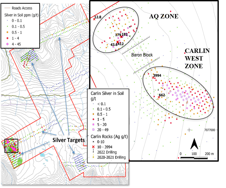
Figure 5. Silver discovery and multiple silver ± gold targets defined at Carlin West.
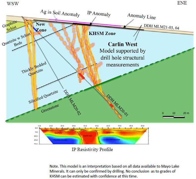
Figure 6. The Carlin West and New Zone at Carlin-Roop.
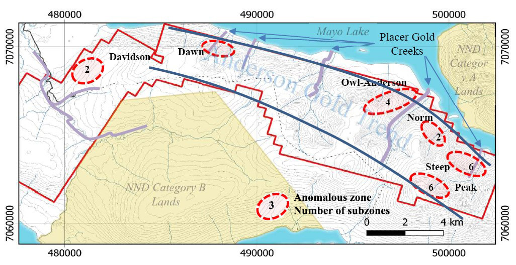
Figure 6a. Anderson-Davidson property with priority area for exploration identified.
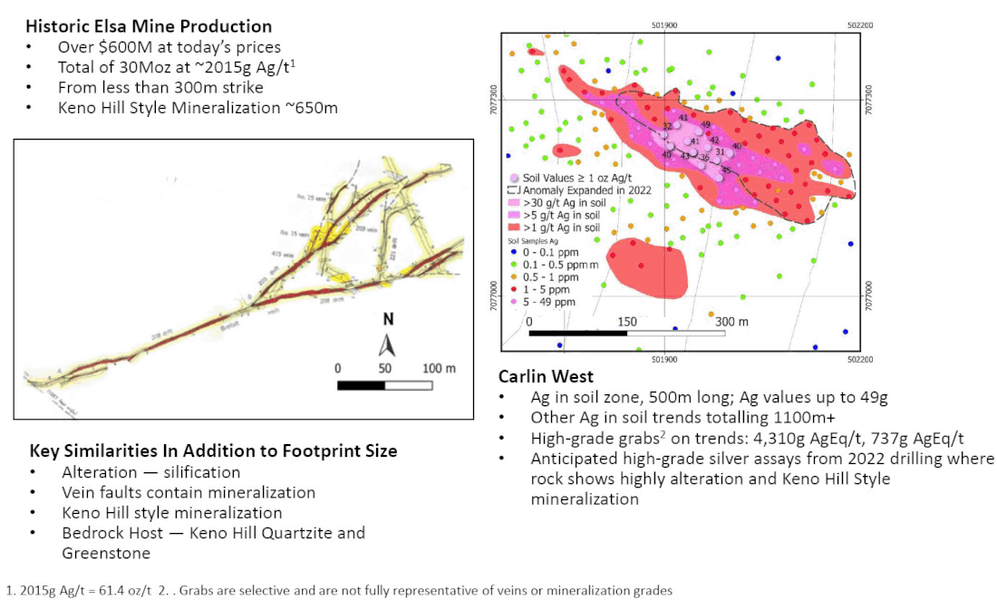
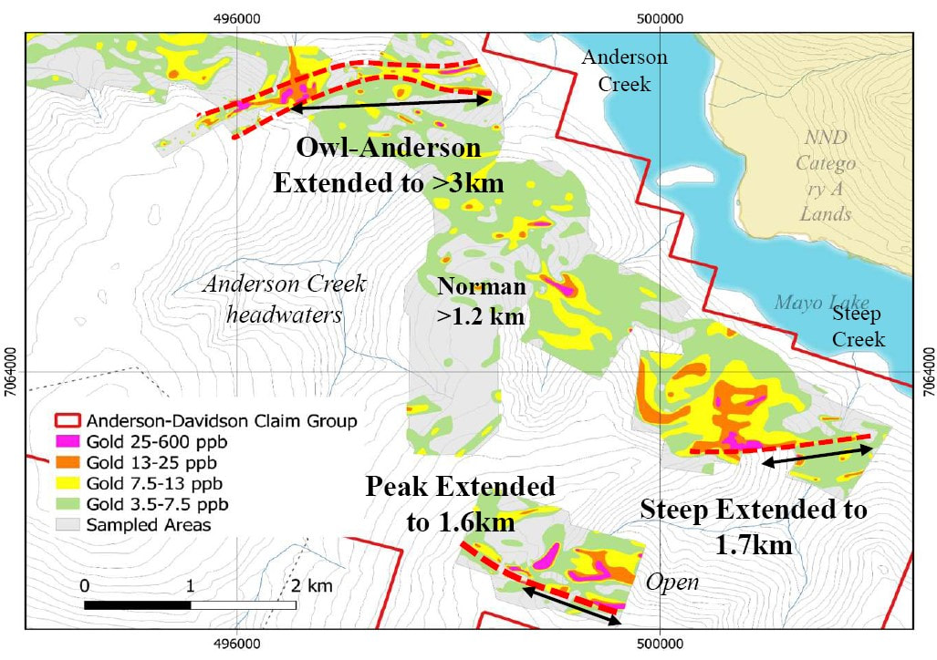
Figure 7. Anderson Gold Belt, Anderson-Owl occurrence and multiple drill gold targets.
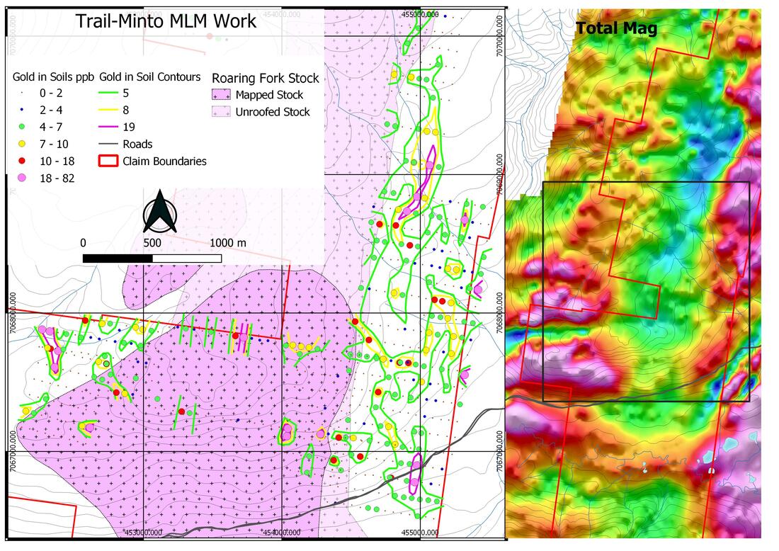
Figure 8. Gold in soil anomalies paralleling Roaring Fork Stock plus representative total magnetic intensity covering Trail-Minto. Note that the magnetic lows coincide with the Stock and its alteration aurora. NNE, NE and E-W linear trends are also obvious on the map.
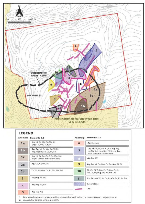
Figure 9. Gold in soil anomalies and their associations with magnetic anomalies and lineation on Edmonton.
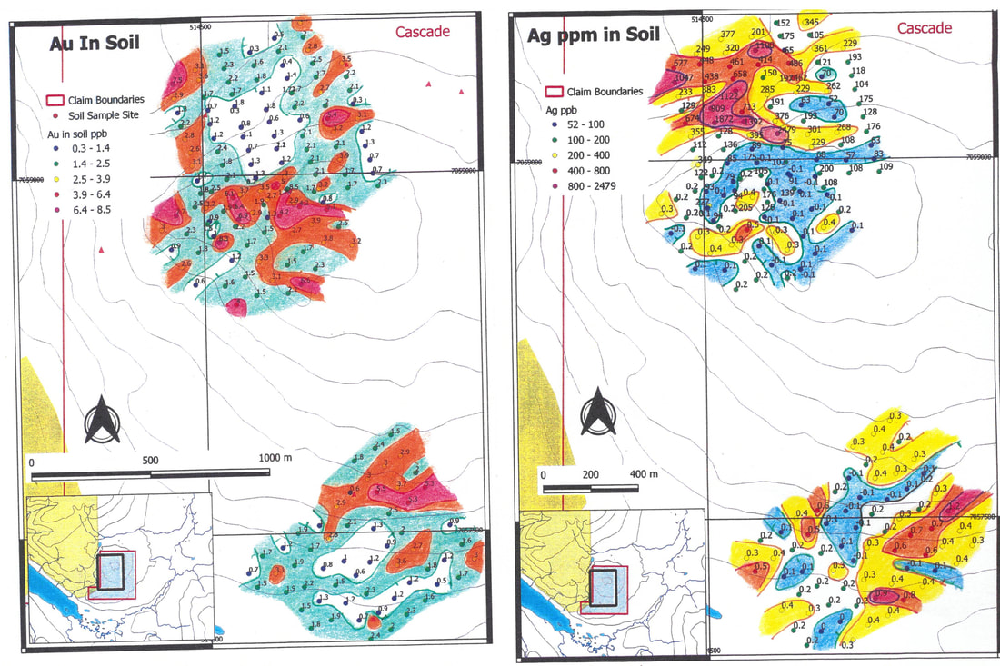
Figure 10. Gold and silver in soils at Cascade. Ag anomaly in NW corner is mirrored by Ni, Cr, Cu, Mo, As, (Au), K, Hg, and Ca; and in SE corner by Ni, Cu, Mo, Mg, K and Hg; E-W Au anomaly in central part of upper grid is mirrored by K, Mg, (Fe), La and Th; and in NE part of lower grid by Zn, W, Mo, Sb, Mn, Mg, (K) and Th; on the E side of the upper grid, a weak N-S Au anomaly is mirroered by Sb, As, K, Hg and Fe. Ca and Mn are very elevated on the southern 2/3 of the lower grid.
|

|
MAILING ADDRESS
Mayo Lake Minerals Box 158, Carp On K0A 1L0 |
|