|
MAYO LAKE MINERALS - YUKON PROPERTIES
SYNOPSIS PROPERTIES FLAGSHIP Carlin-Roop EARLY-MID STAGE Anderson-Davidson Trail-Minto BLUE SKY Edmonton Cascade GEOLOGIC OVERVIEW Yukon Mayo Lake Area Geology Mayo Lake Area Mineralization REPORTS November 17, 2021 Carlin-Roop NI 43-101 Technical Report Carlin-Roop Silver Project, Mayo Lake District, Yukon Territory, Canada |
Geologic Overview
YUKON
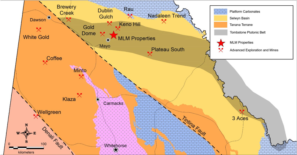
Yukon is a territory in northern Canada that encompasses the boundary of the continental Mackenzie platform and a series of orogenic belts that are collectively known as the North American Cordilleran. The Mackenzie platform is the edge of the long-lived stable North American Craton. It is bounded on the south and west by the Selwyn Basin, which formed from sediment that shed off the craton. The North American Craton collided with several offshore arcs to the west. This resulted in the formation of several exotic terranes, including the Yukon-Tanana Terrane. These collisions caused significant crustal thickening and formation of foreland fold and thrust belts leading to the numerous mountain ranges and associated intrusions to the east of the Yukon Tanana Terrane. Late northward compression led to the Tintina Fault, which offsets the Selwyn Basin and Tombstone Plutonic Suite by up to 700 kilometres across Yukon and Alaska. This complicated structural history has resulted in much of the terrain being fertile for mineralization and mineral deposits (Figure 16). Extensively weathered paleo surfaces form a significant part of today’s landscapes throughout the Yukon and Alaska. Stream incision and related mass wastage and alluvial reworking of eroded sediments has led to the formation of the extensive placer deposits throughout the region.
MAYO LAKE AREA GEOLOGY
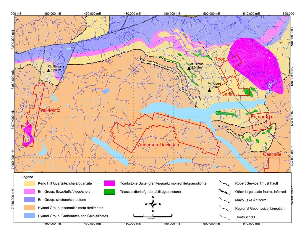
MLM’s properties are located within the Selwyn Basin of the Tintina Gold Belt. Simplified regional geology (Figure 16) depicts Upper Proterozoic to Lower Cambrian Hyland Group stratigraphy in contact with Devonian to early Carboniferous metasedimentary units of the Ern Group and Keno Hill Quartzite along the Robert Service Thrust. Mid-Triassic mafic sills and greenstones are common within the Keno Hill Quartzite and Ern Group, but are rarely encountered in other units (Figure 17). All stratigraphic units have been intruded by the Mid-Cretaceous age Tombstone Plutonic Suite. This Suite host several gold deposits, including Dublin Gulch, a property that lends itself well to a potential open pit resource of 6.4 million ounces of gold at a grade of 0.67 g Au/t. The 100 square kilometre Roop Lakes Stock, west of the Keno Hill Camp, is the largest member of the Tombstone Plutonic Suite and probably drove hydrothermal circulation leading to the mineralization at Keno Hill, as referenced by Roots 1997). The dominant structural features in the area are a pair of imbricated thrust sheets. The Robert Service Thrust (RST) and the Tombstone Thrust Sheet (TTS), which collectively have transported the Selwyn Basin sediments over 150 kilometres to the northeast. The RST Sheet itself contains many internal thrusts that are commonly difficult to distinguish due to subsequent intense folding of faults and contacts and a strong penetrative structural fabric imparted by the later underlying TTS. The area deformed during this event is often referred to as the Tombstone Strain Zone. Intense folding is especially evident in units immediately around Keno Hill. Large open folds — the McQueston Antiform (E-W) and Mayo Lake Antiform (NW-SE) — and several inferred brittle faults were developed after the major thrusting events (Roots 1997).
MAYO LAKE AREA MINERALIZATION
Mineralization within the Tintina Gold Belt is primarily the result of intrusion related gold systems, following the idealized model developed by Hart et al (2002). These large felsic epizonal systems result in variable deposits that on the surface may appear unrelated. Proximal mineralization associated with Tombstone intrusives are sheeted gold veins or stockworks within the rim or immediately adjacent to Tombstone Suite plutons. Intrusion related mineralization itself is generally (i) enriched in Au-Bi-Te, possibly W; (i) depleted in base metals and (iii) situated in tensional zones of the stock. Deposits such as Dublin Gulch, Brewery Creek and Fort Knox are examples of this type of mineralization. The numerous significant gold anomalies surrounding the Roaring Fork Stock could also point to sheeted-vein stockwork type of mineralization. Structurally controlled quartz vein breccias similar to those that comprise Gold Strikes’s Plateau Property and the Pogo Mine in Alaska (4.9 Moz Au @ 12.45 gAu /t) formed after peak metamorphism of the Yukon-Tanana Terrane and range in age from Jurassic to Paleogene. Erosion of these types of veins likely contributed to most of the Klondike and Mayo placer deposits. These breccias form narrow, high-grade deposits and are probably structurally related end-members of the intrusion gold model, in contrast to typical orogenic veins. Quartz vein breccias visible in float along the Anderson Gold Trend likely correspond to this type of structurally related mineralization. Most geochemical and geophysical data that has been collected and compiled on MLM’s claim groups points to structurally related intrusion sources of defined mineralization on the claim groups, specifically the Carlin Roop and possibly the Trail-Minto claim groups. The most distal mineralization associated with these felsic intrusives are polymetallic Ag-Pb-Zn veins, similar to the locally developed Keno Hill Type Veins (KHTV). This mineralization represents the furthest extent of hydrothermal influence related to these intrusions and may occur many kilometres from the source stock. These veins are generally within the Keno Hill Quartzite, but are inferred to cut through the RST and continue into the overlying Hyland Group. All technical information within this document has been reviewed and approved by Dr. Vern Rampton, P. Eng. in his capacity as a qualified person as defined under NI 43-101. __________________________ Hart, C.J.R., McCoy, D.T., Goldfarb, R.J., Smith, M., Roberts, P., Hulstein, R., Bakke, A.A., Bunddtzen, T.K. 2002. Geology, exploration and discovery in the Tintina Gold Province, Alaska and Yukon in Marsh, E.E., Goldfarb, R.J. and Day, W.C. (eds.), Integrated Methods for Discovery; Global Exploration in the Twenty-First Century. Society of Economic Geologists, Special Publication Vol. 9, p. 241-272. Roots, C.F. 1997: Geology of the Mayo Map Area, Yukon Territory (10SM); Exploration and Geological Services Division, Indian and Northern Affairs Canada, Bulletin 7, 82p. |
|
MAILING ADDRESS
Mayo Lake Minerals Box 158, Carp On K0A 1L0 |
|


